Wednesday, December 14, 2011


Fire Island
Later in October, I met with the same faculty member from Stony Brook teaching in the department of Ecology and Evolution and set off to fire island.
While we were on our way out to sea, he said the area has been a hotspot for re-nourishment programs. The National Park Service has been dredging sand from offshore and pumping it onto the beach to make it larger. The reason for this was because the beach has been getting smaller due to various weather conditions and coastal erosion. The project was estimated to cost around 25 million dollars, which will be paid for the by residents of Fire Island through tax increases.
We fished for some striped bass with live eel as bait.


Setauket Mill Pond
In September, I met with a faculty member at the Stony Brook University currently teaching in the department of Ecology and Evolution.
He brought me (and a few others) to the Setauket Mill Pond near the university, where he explained that the ecology of the pond was currently in a crisis. He has been monitoring the state of the pond, and in the past few months, the number of fish in the pond have been drastically decreasing. He says the causes are still unknown, but he predicts it's because people are introducing other species that are not indigenous to the area, therefore effecting the local ecology. That combined with overfishing has helped to reduce the population of the pond to an alarmingly low state. If we leave the pond alone for about two years though, he says the problems can be alleviated, but that doesn't seem likely.
We did some fishing, but we released everything for obvious reasons. We caught largemouth bass, bluegill sunfish, a frog, and some seaweed. We did see two large turtles about 4~5 feet in length. The faculty member told us he had never seen those before, and have probably come in recently.


Tuesday, December 13, 2011
Hudson River from Bear Mountain


During thanksgiving break, I went over to bear mountain to check out the Hudson river.
Near the peak of the mountain, I got a good view of the river and the wildlife surrounding the
 area. There weren't a lot of animals around, but there were some interesting plant life that I found.
There were also a few buildings across the river which might have been either residential or military, as West Point and Fort Montgomery are nearby.
The building that was on top of the mountain is the Perkins Tower, which was completed in 1934 and dedicated to the Chairman of the Palisades Interstate Commission, George W. Perkins. It stands 40 feet tall and is made of stone.


Sunday, December 11, 2011
Thursday, December 8, 2011
Little Neck Bay
I live in Whitestone, near Little Neck and Bayside, so the closest waterway is the Little Neck Bay. It's also a fishery year round, but is most active in the spring to early summer. There used to be a lot of Flounder and Tommy Cod, but due to over fishing, their population has been declining. Other fish in the bay include finfish and shellfish.
The bay serves as a nursery and feeding area for stripped bass, scrup, bluefish, atlantic silversides, menhaden, winter flounder, and blackfish.
However, with the increase of public knowledge in the fact that the bay holds many wildlife, came many more boats and fishers. With the increase in fishing boats, the bay had to construct more piers, docks, bulkheads, and revetments in areas previously undisturbed by development, resulting in the loss of productivity to support the young fish and wildlife. They are currently destroying the natural beaches and salt marshes.
Locals in the area are protesting against the development of the piers and docks, but the town doesn't care because the bay brings in more money for the town.
Wednesday, December 7, 2011
Shad Boat

The American Shad is the largest of the herring family and is the most abundant anadromous fish on the east coast. The Hudson River Shad fishery runs about 40 miles from the George Washington Bridge to Bear Mountain Bridge. It’s abundance made it an important part of New York fishing culture but servants complained about them calling them porcupines turned inside out for all the bones they have.
The Shad Boat is a traditional fishing boat that was referred to as the pick up truck of boats. It traditionally had a round-bottomed hull and single mast rigged with a sprit sail. Shad boats were developed on Roanoke Island and were known for its unique crafting and maneuverability, it was fast, easy to handle and had a shallow hull, making it ideal for upper sounds where water was shallow and weather changed rapidly. Shad boats were generally constructed out of native trees and varied in length between twenty two and thirty three feet.


By: Evan Huang in response to boat post
Why Staten Island is part of NY instead of NJ
In the late 1600's, there was a territorial dispute between NY and NJ over staten island. All the colonies under Dutch rule would fall under English rule - primarily the Duke of York. New Jersey had possession of staten island under Dutch rule, but the Duke of York wanted it under New York.
To settle the dispute, the duke declared that all islands that could be circumnavigated in New York Harbor, would belong to NY. If it took longer, then the island would belong to NJ.
The duke then selected captain Billopp to travel the 35 miles within 24 hours. The captain then proceeded to load his deck with empty barrels, arguing that the extra surface area created by the barrels would help his ship to go faster.
The captain was able to accomplish the run in 23 hours, and so staten island became a part of NY.
Dutch: Governor's Island

In 1633 the fifth director of New Netherland arrived with a 104 men regiment, using Governor’s Island as a military base for the first time. On April 9th 1776, during the Revolutionary War, Continental Army general Israel Putnam fortified the island with earthworks and 40 cannons in preparation for the highly anticipated Battle of Long Island. The island and it’s fortifications were instrumental in discouraging British commanders from entering the East River.


From 1783 to 1966 the island was a U.S. Army post. From 1966 to 1996 it served as a major U.S. Coast Guard installation. And it currently is a national historic landmark with various parts open to the public. Throughout the year, a number of music festivals and large outdoor events are held on Governor’s Island. It is accessible by free ferries from Brooklyn and Manhattan.
By: Evan Huang in response to Old Dutch NY
Stuyvesant Cove Park
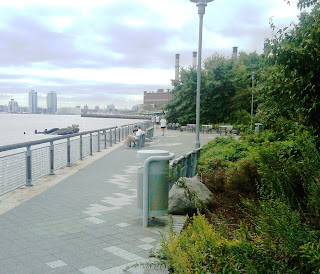
Stuy Cove Park is a small waterside park that runs along the East River from 18th St to 22nd St. It was built on top of a brownfield site that was formerly a cement plant. The park was built after efforts to develop the property into a mixed use Riverwalk development failed. Surplus cement dumped into the east river created a small beach which can be found in the middle of the park.

Stuyvesant Cover Park has a number of benches, vegetation, and walkways with Solar 1 occupying the northern part of the park. The park came to fruition with pressure from area residents who fought for more access to the water. It offers a nice retreat from the East Village with views of Long Island City and the Queensborough Bridge.
By: Evan Huang in response to nearby waterway
Flushing, NY
Currently, I reside in Whitestone, NY near the "Little Bay".
Back in 1609 however, it was considered to be a part of the greater Queens area. Actually, Queens wasn't founded until 1945, but was named "Vlissingen", later renamed "Flushing". At the time, since it remained unsettled until half-way into the 17th century, it would've just been primarily woodlands. However, once the Dutch settlers, and later the English, began to move upwards, there would've been more towns coming up, especially along the bay.
I imagine, since the Dutch and English were primarily Roman Catholic, that would've been the dominant religion. However, a farmer named "John Browne" defied a prohibition at the time set by the New Amsterdam Director - General Peter Stuyversant by allowing Quakers to meet in his home. Others would later defy religious prohibitions, eventually leading to the decision by the Dutch West India Company to allow all religions to worship freely.
East Village / Manhattan in the 1609

By: Evan Huang in response to 1609
Battle of Brooklyn
a.k.a. Battle of Long Island
Because long island stretched from brooklyn to montauk - top point was brooklyn.
First major battle of revoutionary war
Largest battle during war
First battle with the u.s. Army - only one month after declaration
Led by washington
After defeating british in the siege of boston, continental army went to defend nyc, which was only the southern tip of manhattan
Established defenses and waited for british
Wasn't sure whether British will attack manhattan or brooklyn so sent some of his forces to brooklyn. Majority remained in manhattan
In July, british landed in harbor of staten island with 32,000 soldiers.
Washington in comparison had only 6,000 soldiers in brooklyn.
Bulk of his army was in manhattan
In August, the British attacked Guana heights. At the same time, they flanked the Americans from behind. Those who weren't dead or captured retreated to the main defenses in brooklyn heights. Washington then evacuated the entire army to manhattan, but were soon driven out of New York after more defeats and were forced to retreat through New Jersey into Pennsylvania.
When the Americans were being flanked by the British, they were cut off on three sides. The only escape was a salt marsh and a creek that was 80 yards wide on the other side of brooklyn heights. In an effort to buy time, General Stirling and Gist led 400 soldiers in 6 consecutive attacks against the british so the others could get across safely.
More than half of the attacking soldiers died, and the rest were either wounded or captured.
After the retreat, General Washington had to move his forces to Manhattan, where the defenses were stronger. He called 1,200 soldiers stationed in Manhattan to come to Brooklyn. As soon as it became dark, General Washington ordered the 1,200 soldiers to remain at camp and make it look like there were more people. Meanwhile, the remaining 8,000 soldiers began evacuating Brooklyn by crossing the hudson river starting with the sick and wounded first. By morning, all 8,000 solders, including the 1,200 that came to protect the rear went safely across without losing a single life.
Tuesday, December 6, 2011

After doing the reading for this week I found myself dwelling on the
affect that the surrounding woodlands have on the Hudson. The sandbars
that were found in the river after large amounts of forests were chopped
down show how important the surrounding forestry is to the preservation of
the Hudson. I did a little research and found out that New York State
bought 89,000 acres of land from Finch Pruyn & Company (a paper making
company?) in December of 2010. The forested land is located around the
Adirondack Park. This purchase protects this land from development and
will allow for sustainable forest practices. Some of the purchased land will
be available for public recreation in the future! Keeping the trees
surrounding the Hudson alive not only preserves the beautiful landscape but
the quality of the waters flowing through the river. I think it would be really
amazing if the waters and land surrounding it from Tear of the Clouds Lake
to the New York Harbor were clean enough for swimming and other fun
summer activities!
Subscribe to:
Posts (Atom)