I am interested in the conservation of native plants populations within the New York area that are essential to the preservation of these self-sustaining ecosystems. Native plants populations are where adaptations to soil, insects, climate, and disease occur, but with urbanization, they become spatially isolated and may not be able to disseminate pollen. The Greenbelt Native Plant Center in Staten Island (part of the NYC Parks Dept.), has been developing initiatives in native plant restoration with locally appointed seed-banks, providing education and assistance in planning and planting, as well as offering services and resources such as workshops, to enable more public awareness and participation. I would like to find a specific native plant in my research (with the help of the Greenbelt Center and their Native Plant Conservation Initiative) that may be rare or endangered due to their low numbers of individuals and populations. I hope to find qualities in a certain plant that will lend way to restoration in local populations and remediate some of the effects of pollution on biodiversity and self-sustaining populations.
http://www.nycgovparks.org/sub_about/parks_divisions/gnpc/index.html
Showing posts with label Lou. Show all posts
Wednesday, November 30, 2011
Wednesday, November 9, 2011
Blithewood
Blithewood Mansion is a prominent and beautiful feature of the Bard College campus and also home to the Levy Economics Institute of Bard College. Located on the eastern bank of the Hudson, Blithewood occupies a small hamlet within Dutchess County, across the river from Kingston. In 1835, Robert Donaldson of North Carolina bought the property and named the grounds "Blithewood". Donaldson worked with the architects Alexander Jackson and Andrew Jackson Downing to improve the quality of grounds into a landscaped estate, since prior to the acquisition, the property was mostly woods. The landscape architects designed an octagonal gatehouse and a white pine lined driveway that are all that can be seen today of their work. In 1853, John Bard purchased Blithewood and gave a corner of the estate for the founding of St. Joseph's College (becoming Bard in 1934). In 1899, Captain Andrew C. Zabriskie, a cattle breeder, purchased the estate and developed Blithewood as his summer home, physically similar to how the mansion and garden are seen today. He commissioned Francis Hoppin, an alumnus of the architectural firm of McKim, Mead, and White, to design a Beaux-Arts style manor and garden. As a result, Hoppin designed a grandiose mansion and Italian style garden that reflected the architectural elements of English mansion design, with the technology that was present at the turn of the century. It is also interesting to note that there have been long reported noises and poltergeist activity at the mansion. People think they spot a young girl between the ages of 8 and 12 walking around the house and gardens. The apparition is believed to be the daughter of Captain Andrew Zabriskie, who fell to her death out the window of their Manhattan apartment.
Blithewood Mansion
Blithewood gardens
View of gardens, Hudson, and Catskills
Blithewood gardensWednesday, October 26, 2011
River in the Catskills by Thomas Cole
This idyllic setting was painted by Thomas Cole in 1843. One of the founding members of the Hudson River School, Thomas Cole was both a painter and a sculptor working within the artistic styles of romanticism and naturalism. In a time when the Hudson was viewed as an artery of progress and economic prosperity, Cole offered an alternative view of man and nature. This painting depicts man coexisting harmoniously with nature, with very little signs of industrialization or agriculture. The man in foreground is framed by the immensity of the Catskills, emphasizing their magnitude as well as their pacifying qualities. Time stands still in many of Cole's work (as well as other Hudson painters), and these paintings serve to place man within a time and space where he seems to exist without intruding on nature. Cole emotes the tranquility and balance that occurs in nature, with man respectfully enjoying this silence. The vast landscape also fulfills the question of who can enjoy this land. There is a couple people interjected within the painting showing the relation between this immense space and a sparsely populated area. I feel like Thomas Cole was almost advertising this bucolic landscape for certain people.
Wednesday, October 12, 2011
NYCP
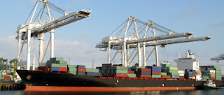
Last Friday, we visited a New York Container Port located on the northwestern tip of Staten Island on Howland Hook, across the Arthur Kill from Elizabeth, NJ. The terminal occupies a 187-acre tract of upland area. The Port Authority of New York turned a brownfield site that was once operated by Proctor and Gamble (manufacturing Ivory soap), into the intermodal terminal it is today. This container port is one of five container ports in the New York/ New Jersey Area and it handles 20% of port traffic on daily basis. On any given day, 10,000 containers pass in and out of the port as imports and exports and these containers are approximately 20 feet long and 8 feet high (known as TEU or twenty-foot equivalent unit, an inexact measurement unit of cargo capacity based on the volume of the containers). According to the NYCT website, the port can handle 425,000 containers annually and can work and unload three vessels simultaneously with seven container cranes. The port is considerably import-driven, however the three main exports coming out of the port are recycled paper, scrap metal, and automobiles and their parts. The terminal is the largest employer in Staten Island and three different unions operate within the terminal.
The New York Container Port is operated by Global Container Terminals, Inc. which was established in 2007 as a fully owned subsidiary of the Ontario Teachers' Pension Plan, one of the largest financial institutions in Canada with over $87 billion in assets. The New York/New Jersey Port Authority has a long term lease agreement with Global Container Terminals who handle the business of the port. The port has its eyes on expansion, targeting an adjacent plot of land known as Port Ivory to provide the necessary area for expansion. However, there are obstacles to expansion such as an Environmental Impact Assessment that has declared the plan environmentally unsound and calls on the terminal to reassess its planning.
There is another obstacle, the Bayonne Bridge located on Kill Van Kull (the primary route to the region's largest shipping terminals) that must be raised or replaced to accommodate the next generation of gigantic container ships. At high tide, the bottom of the bridge is at about 151 feet above water and can accommodate most ships carrying 4000 and 5000 TEU. Often times, if these ships cannot fit at the tide circumstance, they must wait in the Kill Van Kull, incurring costs with long delays. There are already 100 or more ships around the globe that can handle 8,000 TEUs that are double the size of the ships already.
On the New York Container Terminals website, the Terminal boasts several logistical solutions that claim the effectiveness of the terminal. They are the harbor's only facility with on-site warehousing, also with on-site trucking capabilities. The NYCT is also located near the Goethals Bridge, which allows access to four major interstate highways. In addition to the major truck routes, the NYCT also operates a competitive on-dock rail service that connects to the North American intermodal rail service. The website applauds the efficiency and quick turn-around times at the port that allow businesses to run quicker and more efficiently. These logistics allow drivers on average, to move in and out of the terminal within 20 to 30 minutes.
The New York Container Port is operated by Global Container Terminals, Inc. which was established in 2007 as a fully owned subsidiary of the Ontario Teachers' Pension Plan, one of the largest financial institutions in Canada with over $87 billion in assets. The New York/New Jersey Port Authority has a long term lease agreement with Global Container Terminals who handle the business of the port. The port has its eyes on expansion, targeting an adjacent plot of land known as Port Ivory to provide the necessary area for expansion. However, there are obstacles to expansion such as an Environmental Impact Assessment that has declared the plan environmentally unsound and calls on the terminal to reassess its planning.
There is another obstacle, the Bayonne Bridge located on Kill Van Kull (the primary route to the region's largest shipping terminals) that must be raised or replaced to accommodate the next generation of gigantic container ships. At high tide, the bottom of the bridge is at about 151 feet above water and can accommodate most ships carrying 4000 and 5000 TEU. Often times, if these ships cannot fit at the tide circumstance, they must wait in the Kill Van Kull, incurring costs with long delays. There are already 100 or more ships around the globe that can handle 8,000 TEUs that are double the size of the ships already.
On the New York Container Terminals website, the Terminal boasts several logistical solutions that claim the effectiveness of the terminal. They are the harbor's only facility with on-site warehousing, also with on-site trucking capabilities. The NYCT is also located near the Goethals Bridge, which allows access to four major interstate highways. In addition to the major truck routes, the NYCT also operates a competitive on-dock rail service that connects to the North American intermodal rail service. The website applauds the efficiency and quick turn-around times at the port that allow businesses to run quicker and more efficiently. These logistics allow drivers on average, to move in and out of the terminal within 20 to 30 minutes.
Wednesday, October 5, 2011
New Amsterdam
The Dutch legacy in New York is not readily legible in cuisine or certain architecture that has existed through time. Little evidence of the thriving cultural and physical presence of the Dutch is able to be seen, however if you know where to look, their historic presence is everywhere. The ways in which the Dutch viewed their colonization as well as the way they treated the island of Manhattan has a lot to do with how the city has developed today. From 1625 until 1674, the Dutch West India Company, established New Amsterdam as a colony solely to ease the trade route between North America and Europe. This for-profit idea of a colony led to a different form of development and character that the other colonies established for religious or political reasons didn't embody. Although they primarily contributed a legacy of trade, the Dutch also gave Manhattan a "spirit of tolerance", allowing trading partners (whoever they wanted to trade with) to live on the settlement, along with many different people of different religions. The tolerance of the Dutch in Manhattan was partly due to their tolerance of religion in Netherlands where one's religion was not important to being Dutch. Although the Dutch culture and social impacts are not prevalent in the physical space of the city, their intellectual mindset for trade has allowed New York's port's to grow into the dominating force they are today.
statue of henry hudson in the BX
Wednesday, September 21, 2011
Is it kelp?
It’s hard to believe that anything lives in the East River. When I jumped down onto the rocks (the bank) of the East River, I encountered a lot of styrofoam, plastic, nylon, food scraps, and a bunch of refuse that doesn’t look like it’s going anywhere. But upon closer observation, I saw that life flourished in the East River! There were many small flying insects and although I did not see any fish, I can reason that the quality of the East River is not so far gone that it cannot harbor life. But one of the living things that I could recognize was “sea kelp”, large seaweeds that look like attached leaves of lettuce. The kelp were not immense in quantity but there was a good amount of kelp attached to the rocks at the bank of the East River. Sea Kelp is not grouped with aquatic or land plants in classification, but are in either the kingdom Protista or Chromista. Kelp likes to grow in aquatic forests mainly on the Pacific Coast, from Alaska to Canada and in shallow, cool, waters. The conditions they require for growth are usually rocky coastlines (hence seeing them on the East River), and nutrient-rich, waters that range from 42 to 72 degrees Fahrenheit. They have “anchors” that they use to grip onto rock and proceed to grow towards the water surface. The strength of the rock really determines the kelp survival and the kelp can get easily swept away with a storm or other high activity. I think that the kelp I observed were “bull kelp”, which is a species that has one main anchor supporting its many blades nearer to the surface. Bull kelp has an annual life cycle meaning its complete its cycle only once a year. It is interesting to see kelp on the bank of the East River since they do not usually extend southward past Cape Cod on the east coast of North America and are found only sporadically on the eastern tip of Long Island. Could kelp spores have been on a ship coming into the harbor and somehow made there way into the ecosystem of the East River? Seems reasonable but then it makes me question if I was observing kelp and if not, what type of brown algae was this?
Lou
Wednesday, September 14, 2011
To The East
The East River has a rich ecological history that is often overshadowed by the abuse, misuse and degradation that it has suffered throughout industrialization. Commonly known as a “river”, the East River is actually a tidal straight that separates Manhattan and Long Island. The retreat of the Washington glacier 11,000 years ago and the merging of the Atlantic Ocean first created the river. Swirling tides and the narrow channels of the river plagued sailors throughout history and a Dutch explorer, Adrian Block in 1614 gave name to a dangerous midway point in the River, known as “Helegat” (Hell’s Gate), or bright passage. Hell’s Gate was a point of dangerous rocks and subsequent whirlpools where countless ships lie in ruin at the bottom of the river. In 1885, the largest non-atomic explosion caused by man rid the river of the reefs of Hell Gate but the swift currents still made many problems for traveling.
Many communities along the shores of the East River sprouted early due to its great location in relation to New York’s harbors and the rest of the world. The river sheltered and fostered industries that spread American commerce all over the world and became a major site for immigration into New York. But the river has throughout history been a site of abundant source of life and environmental interactions. Native Americans fished extensively in the river, as well as sustained cultures through a vast network of trading extending all the way to the Carribean. European settlers and cattle used the river ceremoniously and the tidal energy through the marshes turned mills on Dutch colonial farms. It is almost hard to imagine this idyllic place in relation to the state of the river today, from the heavy polluting of industrial waste to unrestricted dumping that continues to plague this tidal straight.
There are many islands that line the East River, and these islands have been important sites of “out of sight, out of mind” mentalities that exist in the city. They have been used as such due to the rivers intrinsic tidal current that can “sweep” these unwanted conditions and people away from society. Riker’s Island, located between Bronx and Queens, was purchased in 1884 and was originally a landfill. Currently it is the Department of Corrections main base of operation. North Brother Island housed “Typhoid Mary Mallon”, who was instituted on the island until death to prevent the outbreak of her disease into society. Blackwell’s Island, known now as Roosevelt Island, held a smallpox hospital, a prison, and housed one of the biggest Insane Asylum’s in New York, which held double its carrying capacity in inmates.
Hell Gate being blasted in October, 1885
Wednesday, September 7, 2011
Back in the Day
East 5th St. is a beautiful block by todays standards. There are relatively young, mature Oaks and Maples about every 10 or so feet and the local east side community organizations do an excellent job keeping these trees in tact. Adding to a sense of a quiet, well kept environment, the block is primarily residential with a couple businesses located at the ground floor. But in 1609, this block would have been completely unsustainable to human habitat and its inhabitants would have belonged to very diverse communities. Virginia Creepers, Strawberry Bushes, Red Maples, Black Cherries, Limber Honeysuckles, Oaks, and Tulip trees dominated the regions flora. Black Bears, White-tailed Deer, Brown Snakes, and Meadow Voles most likely roamed the streets in abundance. There were no trails near the area and the distance to the nearest Native encampment was about 1500 meters leading me to believe that this area was a region rich in biodiversity and accessible mainly to the life supporting the ecosystem. Although plants and animals were the primary occupants, with fruit bearing species like Blackgum, Chokeberry, Summer Grapes, and Honeysuckle populating the area, I believe this block would have been a great place for gathering and was probably used as such.
Lou
Lou
Subscribe to:
Posts (Atom)